

YOUR GUIDE TO COLORADO’S
BEST SKIING
This handy-dandy guide is here to help you decide which slopes you want to celebrate on! Whether you want to say your vows on top of a mountain, replace your first dance with a first ski, or propose to the one you love, there is a perfect mountain for you. A lot of factors are involved in picking your place, so scroll on to read all the details about all the ski resorts in Colorado.
ALL of THE SKI RESORTS IN COLORADO

ARAPAHOE BASIN
Dillon, CO | Summit County

Arapahoe Basin (or as most say, A-Basin) is known for having the longest ski season in Colorado. In July of 2019, they were open on the 4th of July and had an awesome celebration. In October of 2019, only mere hours after its neighbor Keystone announced they were opening earlier than anticipated for the 19/20 season, A-Basin announced they would be opening a few hours earlier to be the first. A-Basin has a fun, relaxed atmosphere and a great tailgating area called “The Beach” at the base of the mountain. A-Basin isn’t has big as its neighbors in Summit County, but this lends to its desirability as it is usually less crowded.
Mountain STATS
Base Elevation: 10,780’
Summit Elevation: 13,050’
Vertical Drop: 2,530’
Trails: 147
Lifts: 9
Difficulty Level:
Green: 7%
Blue: 20%
Black: 49%
Double Black: 24%
Terrain Parks: 3
Acres: 1,428
Average Snowfall: 336”
THE LOGISTICS
Season: Typically begins late October, the season usually ends in June (but sometimes they stay open through the Fourth of July)
Hours of Operation: 8:30am - 4:00pm
First Chair: 9am
Pass: Ikon Pass, A-Basin Pass
Lift Ticket: $105
TRAVEL INFORMATION
Distance from Denver: 64 miles
Distance from the Denver Airport: 89 miles
Distance from Colorado Springs: 130 miles
Distance from Fort Collins: 124 miles
Distance from Boulder: 75 miles
Closest Towns: Dillon, Silverthorne, Frisco
Nearby Ski Resorts: Loveland, Keystone, Breckenridge, Copper
Things to do: Go dogsledding, go on a snowmobiling tour, sip some hot cocoa on a sleigh ride.
ASPEN snowmass
Snowmass Village, CO | Pitkin County

Aspen Snowmass offers four mountains under one ticket: Aspen Mountain (Ajax), Snowmass, Buttermilk, and Aspen Highlands. It is the playground to the rich and famous, and has a high-end feel. It was voted one of the top 10 ski resorts in North America by Forbes.
ASPEN SNOWMASS
Base Elevation: 8,104’
Summit Elevation: 12,510’
Vertical Drop: 4,406’
Trails: 336
Lifts: 40
Difficulty Level:
Green: 5%
Blue: 48%
Black: 17%
Double Black: 30%
Terrain Parks: 10
Acres: 3,339'
Average Snowfall: 300”
THE LOGISTICS
Season: The season typically opens late November/early December and usually ends in April
Hours of Operation: 9:00am - 3:30pm
First Chair: 8:30am, Sam’s Knob
Pass: Ikon Pass, Aspen Snowmass Season Pass
Lift Ticket: $149
TRAVEL INFORMATION
Distance from Denver: 197 miles
Distance from the Denver Airport: 227 miles
Distance from Colorado Springs: 165 miles
Distance from Fort Collins: 256 miles
Distance from Boulder: 208
Distance from Grand Junction: 128 miles
Closest Towns: Aspen, Snowmass, Basalt
Things to do: Recover from a long day of skiing at the Rèmede Spa at The St. Regis Aspen, then take a horse-drawn sleigh ride to lunch or dinner at the Pine Creek Cookhouse.
Beaver Creek
Beaver Creek, CO | Eagle County
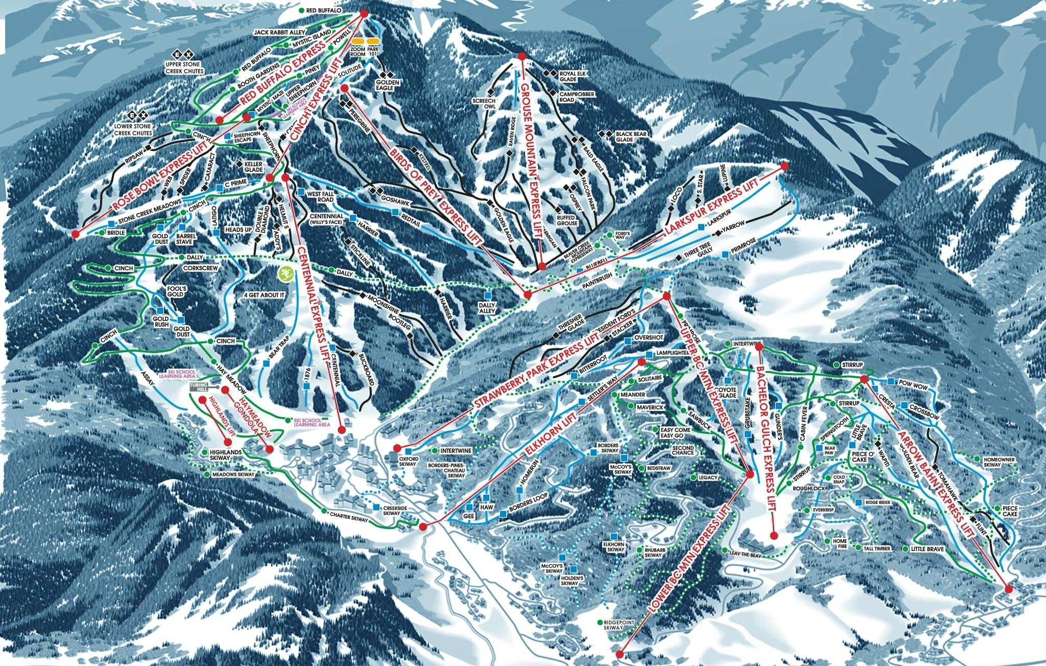
Beaver Creek is a luxury resort, just 10 minutes west of Vail. It was chosen as one of the top 10 resorts in America by SnowPak. They are known for giving a way free, fresh-baked chocolate chip cookies every day at 3pm in the village and at the base of Centennial Express.
Mountain STATS
Base Elevation: 8,100’
Summit Elevation: 11.440’
Vertical Drop: 3,340’
Trails: 150
Lifts: 23
Difficulty Level:
Green: 38%
Blue: 30%
Black: 24%
Double Black: 8%
Terrain Parks: 3
Acres: 1,832’
Average Snowfall: 325”
THE LOGISTICS
Season: Typically opens late November, the season usually ends mid-April
Hours of Operation: 9:30am - 4:30pm
Pass: Epic Pass
Lift Ticket: $109 - $189
TRAVEL INFORMATION
Distance from Denver: 109 miles
Distance from the Denver Airport: 140 miles
Distance from Colorado Springs: 152 miles
Distance from Fort Collins: 169 miles
Distance from Boulder: 120 miles
Closest Towns: Beaver Creek, Avon, Vail, Edwards, Minturn
Nearby Ski Resorts: Vail
Things to do: Go ice skating in the village, relax at the Allegria Spa, take a ride on a snowcat to Beano’s Cabin for a 5-course gourmet dinner.
Breckenridge
Breckenridge, CO | summit County
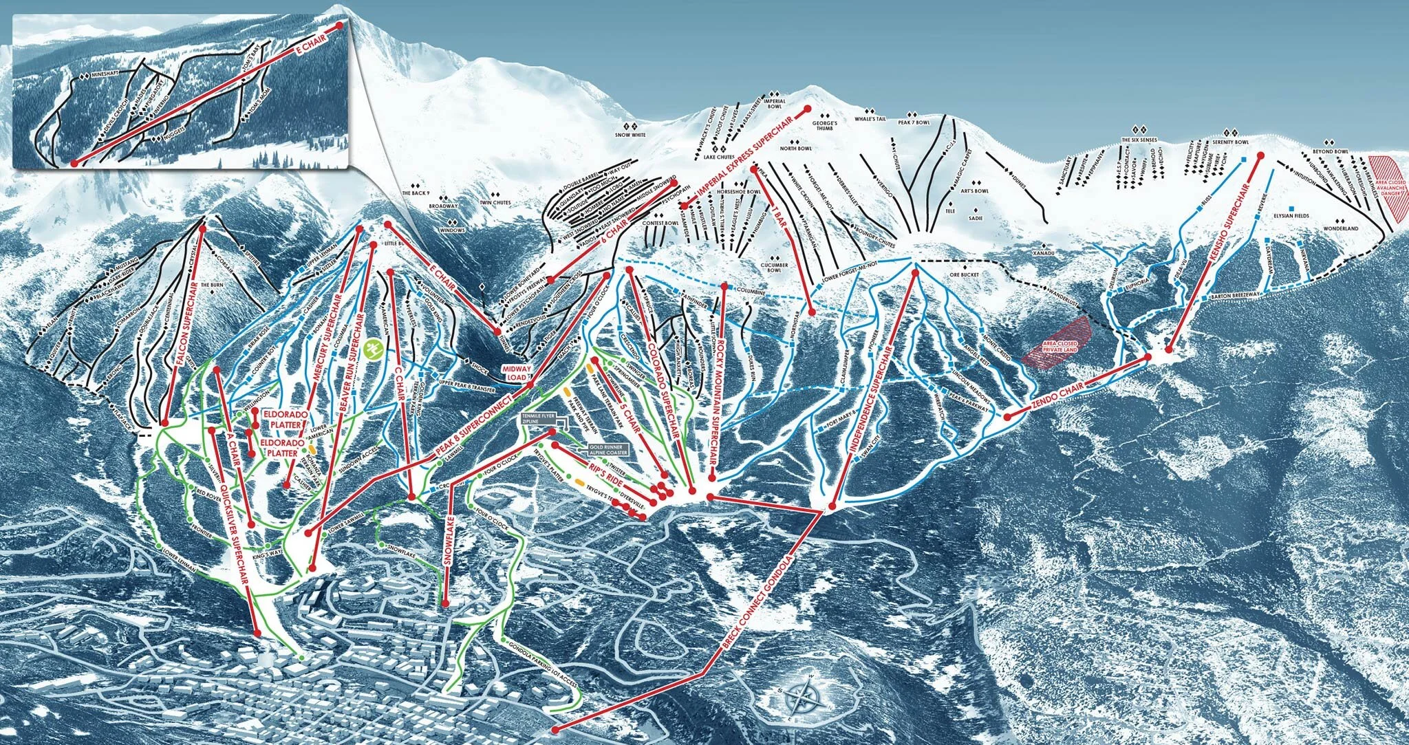
Breckenridge offers 5 different peaks with trails for all experience levels, from groomers to bowls. It was voted one of the top 10 ski resorts in America by SnowPak. At the base of the mountain is the charming town of Breckenridge, filled with great restaurants and shops.
Mountain STATS
Base Elevation: 9,600’
Summit Elevation: 12,998’
Vertical Drop: 3,398’
Trails: 187
Lifts: 34
Difficulty Level:
Green: 13%
Blue: 23%
Black: 36%
Double Black: 28%
Terrain Parks: 4
Acres: 2,908
Average Snowfall: 300”
THE LOGISTICS
Season: Typically opens mid November, the season usually ends in late May
Hours of Operation: 8:30am - 4:00pm
Pass: Epic Pass, Summit Value Pass
Lift Ticket: $109 - $173
TRAVEL INFORMATION
Distance from Denver: 80 miles
Distance from the Denver Airport: 104 miles
Distance from Colorado Springs: 106 miles
Distance from Fort Collins: 140 miles
Distance from Boulder: 92 miles
Closest Towns: Breckenridge, Frisco, Silverthorne, Dillon
Nearby Ski Resorts: Copper, Keystone, A-Basin
Things to do: Grab some breakfast at (the very popular) Crepes a la Carte, check out some sculptures at the International Snow Sculpture Championships (the last week in January), have a romantic dinner in a 120 year old Victorian house at the Hearthstone Restaurant, visit the Breckenridge Distillery for a tasting and a tour.
Copper Mountain
Frisco, CO | summit County

Copper is known for its naturally-divided terrain, which makes it easy to stick to the level of difficulty you prefer. Copper also offers several six terrain parks.
Mountain STATS
Base Elevation: 9,712’
Summit Elevation: 12,313’
Vertical Drop: 2,738’
Trails: 150
Lifts: 24
Difficulty Level:
Green: 25%
Blue: 24%
Black: 34%
Double Black: 17%
Terrain Parks: 6
Acres: 2,527
Average Snowfall: 300”
THE LOGISTICS
Season: Typically ends mid to late November, the season usually ends mid to late April
Hours of Operation: 8:30am - 4:00pm (9:00am weekdays)
Pass: Ikon Pass, Copper Season Pass
Lift Ticket: $134 - $178
TRAVEL INFORMATION
Distance from Denver: 78 miles
Distance from the Denver Airport: 109 miles
Distance from Colorado Springs: 121 miles
Distance from Fort Collins: 138 miles
Distance from Boulder: 89 miles
Closest Towns: Frisco, Silverthorne, Dillon
Nearby Ski Resorts: Vail, Breckenridge, Keystone
Things to do: take a ride on the Rocky Mountain Coaster, Visit the ice castles in Dillon, go dogsledding, go on a snowmobiling tour, sip some hot cocoa on a sleigh ride.
Ski COoper
Leadville, CO | lake County
Ski Cooper has all-natural snow and is a family-friendly resort. It is smaller than the above resorts, which makes it a much more affordable option.
Mountain STATS
Base Elevation: 10,500’
Summit Elevation: 11,700’
Vertical Drop: 1,200’
Trails: 41
Lifts: 4
Difficulty Level:
Green: 18%
Blue: 30%
Black: 23%
Double Black: 28%
Terrain Parks: 1
Acres: 400
Average Snowfall: 260”
THE LOGISTICS
Season: Typically opens early to mid December, the season usually ends mid to late April
Hours of Operation: 9:00am - 4:00pm
Pass: Cooper Ski Pass
Lift Ticket: $49 - $62
TRAVEL INFORMATION
Distance from Denver: 109 Miles
Distance from the Denver Airport: 132 miles
Distance from Colorado Springs: 137 miles
Distance from Fort Collins: 168 miles
Closest Towns: Leadville
Things to do: Grab some food at Treeline Kitchen, Go on a snowmobiling tour, take a drive out to the beautiful Twin Lakes.
CRESTED BUTTE
Crested Butte, CO | Gunnison County

Crested Butte may not have the convenience of being located along I-70, but both the mountain and quaint town are worth the trip. Crested Butte has a laid-back, local vibe and is less crowded than its more conveniently located counterparts.
Mountain STATS
Base Elevation: 9,375’
Summit Elevation: 12,162’
Vertical Drop: 3,062’
Trails: 121
Lifts: 14
Difficulty Level:
Green: 14%
Blue: 25%
Black: 25%
Double Black: 36%
Terrain Parks: 4
Acres: 1,547'
Average Snowfall: 234”
THE LOGISTICS
Season: Typically opens late November, the season usually ends early April
Hours of Operation: 9:00am - 4:00pm
First Chair: 9:30am, Red Lady Express
Pass: Epic Pass, Keystone/Crested Butte 4-Pack
Lift Ticket: $109 - $113
TRAVEL INFORMATION
Distance from Denver: 228 miles
Distance from the Denver Airport: 259 miles
Distance from Colorado Springs: 194 miles
Distance from Fort Collins: 288 miles
Distance from Montrose: 92 miles
Distance from Grand Junction: 152 miles
Closest Towns: Crested Butte, Gunnison
Things to do: On your way to Crested Butte, grab burger in Gunnison at local favorite Power Stop, take walk around town, get some pizza at Secret Stash, go Snowshoeing or Dogsledding, go on a tour at the Montoya Rum Distillery, take a Sleigh Ride.
ECHO MOUNTAIN PARK
IDAHO SPRINGS, CO | Clear Creek County

Echo Mountain Park may be small, but it is the closest ski mountain to Denver, making it a a convenient option to get a few runs in without the commute. The also offer night skiing with an awesome view of the stars.
Mountain STATS
Base Elevation: 10,050’
Summit Elevation: 10,650’
Vertical Drop: 600’
Trails: 8
Lifts: 3
Difficulty Level:
Green: 5%
Blue: 75%
Black: 15%
Double Black: 5%
Terrain Parks: 1
Acres: 60
Average Snowfall: 275”
THE LOGISTICS
Season: Typically opens late November, season usually ends mid April
Hours of Operation: 9:00 am - 5:00pm (1o:00am weekdays) Closed Mondays
Pass: Echo Mountain Season Pass
Lift Ticket: Learn more here
TRAVEL INFORMATION
Distance from Denver: 36 miles
Distance from the Denver Airport: 67 miles
Distance from Colorado Springs: 102 miles
Distance from Fort Collins: 96 miles
Distance from Boulder: 47 miles
Closest Towns: Idaho Springs, Georgetown
Things to out of ski boots: Go tubing on the mountain. Get some pizza at Beau Jo’s and dip the crust in some honey! Visit the Indian Hot Springs, and take a train ride on the Georgetown Loop.
Eldora
NEDERLAND, CO | BOULDER County

Eldora is the closest ski mountain to Boulder, and only a little over an hour drive from Denver. It offers a laid-back atmosphere with a more affordable price tag.
Mountain STATS
Base Elevation: 9,200’
Summit Elevation: 10,600’
Vertical Drop: 1,400’
Trails: 65
Lifts: 10
Difficulty Level:
Green: 18%
Blue: 43%
Black: 18%
Double Black: 20%
Terrain Parks: 8
Acres: 680
Average Snowfall: 311”
THE LOGISTICS
Season: Typically opens late November, the season usually ends late April
Hours of Operation: 8:30am - 4:00pm (9:00am weekdays)
Pass: Ikon Pass, Alpine 4-Pack
Lift Ticket: $89 - $129
TRAVEL INFORMATION
Distance from Denver: 49 miles
Distance from the Denver Airport: 64 miles
Distance from Colorado Springs: 115 miles
Distance from Fort Collins: 70 miles
Distance from Boulder: 21 miles
Closest Towns: Nederland, Ward
Things to do: Visit the Carousel of Happiness, drive the Peak to Peak Scenic Byway, grab a beer at Very Nice Brewing Company, get some coffee or a treat at the Train Cars Coffee and Yogurt Company.
Granby Ranch
Granby, CO | Grand County

Granby Ranch is a family-owned ski mountain located just outside of Rocky Mountain National Park, and offers terrain for all skill levels.
Mountain STATS
Base Elevation: 8,202’
Summit Elevation: 9,202’
Vertical Drop: 1,000’
Trails: 40
Lifts: 5
Difficulty Level:
Green: 36%
Blue: 40%
Black: 24%
Double Black: 0%
Terrain Parks: 1
Acres: 170
Average Snowfall: 220”
THE LOGISTICS
Season: Typically opens mid December, the season usually ends in April
Hours of Operation: 9:00am - 4:00pm
Lift Ticket: $84 - $89
TRAVEL INFORMATION
Distance from Denver: 86 miles
Distance from the Denver Airport: 110 miles
Distance from Colorado Springs: 152 miles
Distance from Fort Collins: 146 miles
Closest Towns: Granby, Fraser, Winter Park, Grand Lake
Nearby Ski Resorts: Winter Park
Things to do: Go on a winter hot air balloon ride, soak in some hot springs, have a lakeside dinner at the Historic Rapids Lodge Restaurant.
KEYSTONE
Keystone, CO | summit County
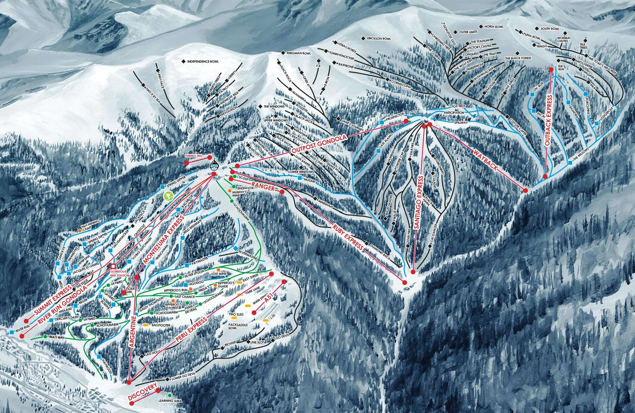
Keystone is known for having the longest ski day in the state of Colorado, due to their night skiing. They offer $10 cat rides to the bowls and glades, and have a terrain park with its own lift. Keystone was voted one of the top 10 ski resorts in America by SnowPak.
Mountain STATS
Base Elevation: 9,280’
Summit Elevation: 12,408’
Vertical Drop: 3,128’
Trails: 128
Lifts: 20
Difficulty Level:
Green: 16%
Blue: 43%
Black: 41%
Double Black: 0%
Terrain Parks: 1
Acres: 3,148
Average Snowfall: 235”
THE LOGISTICS
Season: Typically opens late October, the season usually ends in early April
Hours of Operation: 9:00am - 4:00pm (Night skiing til 8:00pm on select days)
First Chair: 8:30am
Pass: Epic Pass, Keystone Plus and Summit Value Pass
Lift Ticket: $109 - $139
TRAVEL INFORMATION
Distance from Denver: 75 miles
Distance from the Denver Airport: 99 miles
Distance from Colorado Springs: 141 miles
Distance from Fort Collins: 135 miles
Distance from Boulder: 86 miles
Closest Towns: Frisco, Silverthorne, Dillon
Nearby Ski Resorts: Copper, Breckenridge, A-Basin
Things to do: Visit the ice castles in Dillon, go dogsledding, go on a snowmobiling tour, sip some hot cocoa on a sleigh ride.
LOVELAND ski area
dillon, CO | summit County

Loveland is an intimate ski area as the base of Loveland Pass. It’s known for its uncrowded trails, and free snow cat rides to their most difficult terrain.
Mountain STATS
Base Elevation: 10,800’
Summit Elevation: 13,010’
Vertical Drop: 2,210’
Trails: 94
Lifts: 10
Difficulty Level:
Green: 13%
Blue: 41%
Black: 20%
Double Black: 26%
Terrain Parks: 1
Acres: 240
Average Snowfall: 422”
THE LOGISTICS
Season: Typically opens late October/early November, the season usually ends in early May
Hours of Operation: 8:30am - 4pm (9:00am weekdays)
First Chair: 8:30am/9:00am
Pass: Loveland Ski Pass, Loveland 4-pack
Lift Ticket: $75
TRAVEL INFORMATION
Distance from Denver: 57 miles
Distance from the Denver Airport: 80 miles
Distance from Colorado Springs: 122 miles
Distance from Fort Collins: 116 miles
Distance from Boulder: 68 miles
Closest Towns: Georgetown, Dillon, Silverthorne
Nearby Ski Resorts: A-Basin, Keystone
Things to do: Take a train ride on the Georgetown Loop, visit the ice castles in Dillon, go dogsledding, go on a snowmobiling tour, sip some hot cocoa on a sleigh ride.
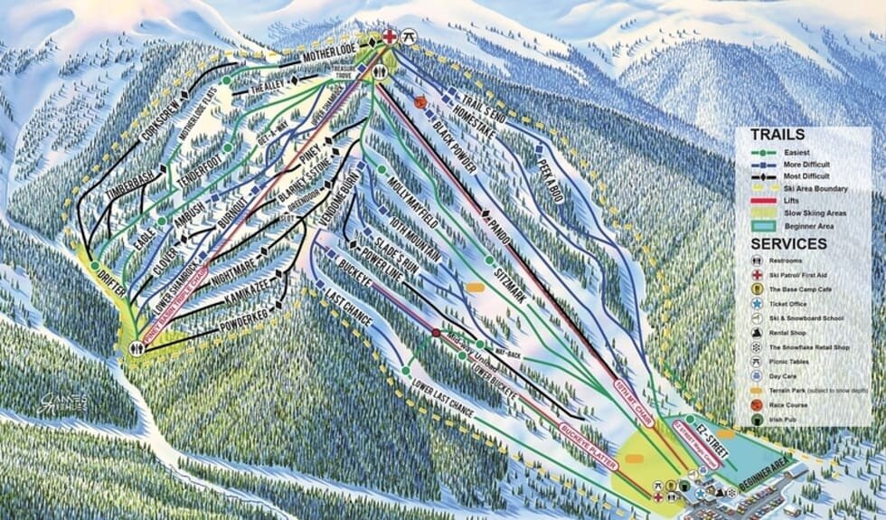
Monarch Mountain
Salida, CO | Chafee County

Monarch is a small, independent mountain with trails for all experience levels. It is located on Monarch Pass along the continental divide. Away from the I-70 corridor, it is less crowded than some of the bigger mountains.
Mountain STATS
Base Elevation: 10,790’
Summit Elevation: 11,952’
Vertical Drop: 1,162’
Trails: 64
Lifts: 8
Difficulty Level:
Green: 23%
Blue: 28%
Black: 36%
Double Black: 13%
Terrain Parks: 2
Acres: 800
Average Snowfall: 350”
THE LOGISTICS
Season: Typically opens early to mid December, the season usually ends mid to late April
Hours of Operation: 8:00am - 4:30pm
First Chair: 9:00am
Pass: Monarch Season Pass
Lift Ticket: $72 - $94
TRAVEL INFORMATION
Distance from Denver: 157 miles
Distance from the Denver Airport: 181 miles
Distance from Colorado Springs: 123 miles
Distance from Fort Collins: 217 miles
Distance from Boulder: 168 miles
Distance from Gunnison: 44 miles
Closest Towns: Salida, Buena Vista
Things to do: Soak in some hot springs, go dog sledding, take a snowmobiling tour.
Powderhorn Resort
MESA, CO | mesa County
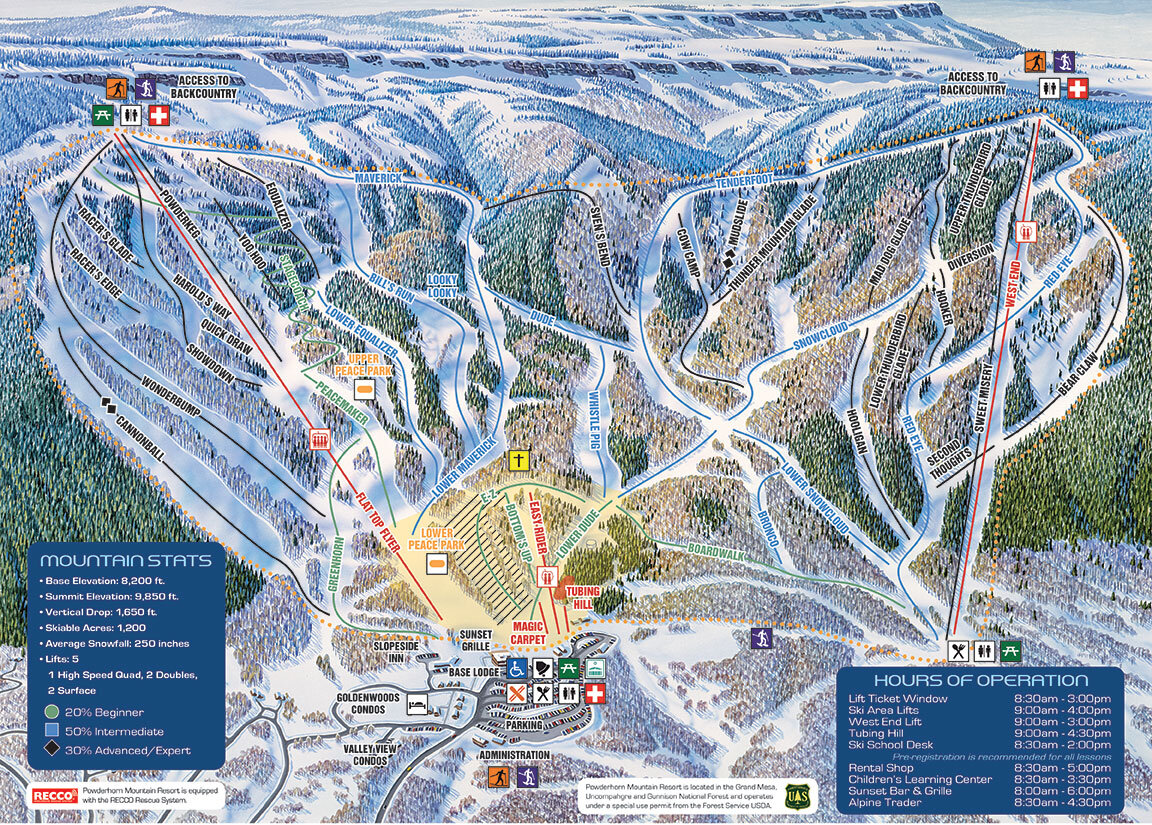
Powderhorn is the closest ski area to Grand Junction. They offer more affordable passes, and the mountain is less crowded than other Colorado mountains.
Mountain STATS
Base Elevation: 8,200’
Summit Elevation: 9,850’
Vertical Drop: 1,650’
Trails: 42
Lifts: 5
Difficulty Level:
Green: 20%
Blue: 50%
Black: 20%
Double Black: 10%
Terrain Parks: 2
Acres: 1,600
Average Snowfall: 250”
THE LOGISTICS
Season: Typically opens late November/early December, the season usually ends in late March
Hours of Operation: 9:00am - 4:00pm
Pass: Mission Affordable Pass
Lift Ticket: $49 - $71
TRAVEL INFORMATION
Distance from Denver: 233 miles
Distance from Colorado Springs: 298 miles
Distance from Grand Junction: 39 miles
Distance from Durango: 174 miles
Distance from Montrose: 67 miles
Closest Towns: Palisade, Grand Mesa, Grand Junction
Things to do: Have dinner and and a beer at the Rockslide Brew Pub, grab some legendary toffee at Enstrom’s, catch a show at the Avalon Theater.
Purgatory Resort
Durango, CO | la plata County
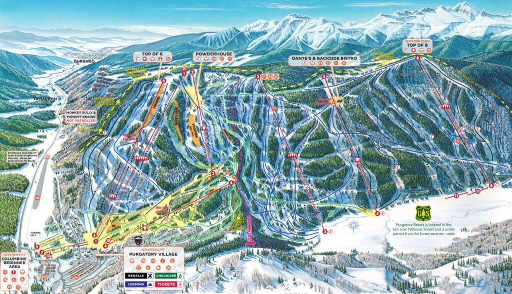
Purgatory was voted “America’s Best Ski Value” by TripAdvisor and offers terrain for every skill level.
Mountain STATS
Base Elevation: 8,793’
Summit Elevation: 10,822’
Vertical Drop: 2,029’
Trails: 101
Lifts: 12
Difficulty Level:
Green: 20%
Blue: 45%
Black: 30%
Double Black: 5%
Terrain Parks: 9
Acres: 1,605
Average Snowfall: 260”
THE LOGISTICS
Season: Typically opens late November, the season usually ends late April/early May
Hours of Operation: 9:00am - 4:00pm
Pass: Purgatory Season Pass
Lift Ticket: $99
TRAVEL INFORMATION
Distance from Denver: 363 miles
Distance from the Denver Airport: 387 miles
Distance from Colorado Springs: 342 miles
Distance from Grand Junction: 141 miles
Closest Towns: Durango, Silverton
Nearby Ski Resorts: Silverton Mountain
Things to do: Take a winter train ride, soak in the hot springs and relax at the spa, grab some beer and food at the Animas Brewing Company.
Silverton Mountain
Silverton, co | san juan County

Silverton Mountain is like no other in Colorado- it is advance only terrain with no formal trails. There is both unguided and guided ski options, as well as single drop and 6-run Heli Skiing.
Mountain STATS
Base Elevation: 10,400’
Summit Elevation: 13,487’
Vertical Drop: 3,087’
Trails: 69
Lifts: 1
Difficulty Level:
Green: 0%
Blue: 0%
Black: 100%
Double Black: 100%
Terrain Parks: 0
Acres: 26,819
Average Snowfall: 400”
THE LOGISTICS
Season: Heli skiing opens late November, guided season is December - March, Unguided season is Wednesday to Sunday through March 16 - April 17, 2022
Hours of Operation: 9:00am - 4:00pm
Guided Skiing Lift Ticket: $184
Unguided Skiing Lift Ticket: $84
Heli Skiing: more information here
TRAVEL INFORMATION
Distance from Denver: 330 miles
Distance from Colorado Springs: 296 miles
Distance from Durango: 54 miles
Distance from Grand Junction: 126 miles
Closest Towns: Silverton, Durango
Nearby Ski Resorts: Purgatory
To Do: Visit the Shangri-La Soaking Pools, grab a beer at the Avalanche Brewing Company, take a winter train ride.
STEAMBOAT
Steamboat Springs, CO | routt County

Steamboat was voted “America’s Best Ski Town” by Powder Magazine. The mountain offers a little bit for everyone, and if you like glades, you can ski through a forest of aspen trees. Getting to Steamboat Springs is a bit of a trek compared to the convenience of the I-70 resorts, but the journey is worth it. Steamboat has a laid-back vibe and an awesome little town to explore after a day of skiing.
Mountain STATS
Base Elevation: 6,900’
Summit Elevation: 10,568’
Vertical Drop: 3,668’
Trails: 169
Lifts: 18
Difficulty Level:
Green: 14%
Blue: 42%
Black: 44%
Double Black: 0%
Terrain Parks: 4
Acres: 2,965’
Average Snowfall: 336”
THE LOGISTICS
Season: Typically opens late November, the season usually ends mid April
Hours of Operation: 8:00am - 4:00pm
Pass: Ikon Pass
Lift Ticket: more information here
TRAVEL INFORMATION
Distance from Denver: 154 miles
Distance from the Denver Airport: 178 miles
Distance from Colorado Springs: 220 miles
Distance from Fort Collins: 156 miles
Distance from Boulder: 166 miles
Closest Towns: Steamboat Springs
Things to out of ski boots: Relax in the gorgeous Strawberry Park Hot Springs, grab dinner at Table 79 Foodbar, go dog sledding, take a scenic helicopter tour.
SUNLIGHT
Glenwood springs, CO | Garfield County
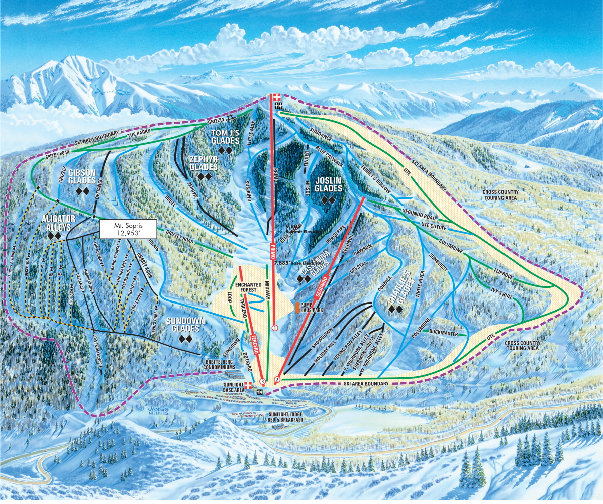
Sunlight is a secret gem in Colorado, with challenging advance trails as well as great options for beginners.
Mountain STATS
Base Elevation: 7,885’
Summit Elevation: 9,895’
Vertical Drop: 2,010’
Trails: 67
Lifts: 3
Difficulty Level:
Green: 18%
Blue: 32%
Black: 18%
Double Black: 32%
Terrain Parks: 1
Acres: 680
Average Snowfall: 250”
THE LOGISTICS
Season: Typically opens late November/early December, season ends in early April
Hours of Operation: 9:00am - 4:00pm
Pass: Sunlight Season Pass
Lift Ticket: more information here
TRAVEL INFORMATION
Distance from Denver: 170 miles
Distance from the Denver Airport: 193 miles
Distance from Colorado Springs: 235 miles
Distance from Fort Collins: 229 miles
Distance from Grand Junction: 99 miles
Closest Towns: Glenwood Springs, Carbondale
Nearby Ski Resorts: Aspen Snowmass
Things to out of ski boots: Recover from a day of skiing at the Glenwood Hot Springs, relax at La Provence Spa, grab dinner at the Pullman.
Telluride
Telluride, CO | San Miguel County
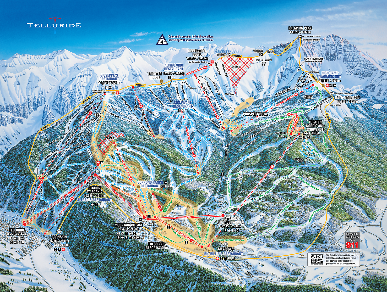
Telluride has an adorable historic downtown tucked up against the mountains and offers incredible skiing. The mountain has a luxurious, upscale vibe which makes a trip here feel special! Located in the South West quadrant of Colorado, it can be a bit of a journey to get there, but worth the trip.
Mountain STATS
Base Elevation: 8,725’
Summit Elevation: 13,150’
Vertical Drop: 4,425’
Trails: 148
Lifts: 17
Difficulty Level:
Green: 16%
Blue: 29%
Black: 21%
Double Black: 34%
Terrain Parks: 3
Acres: 2,000
Average Snowfall: 280”
THE LOGISTICS
Season: Typically opens late November, the season usually ends early April
Hours of Operation: 9:00am - 4:00pm
Pass: Telluride Season Pass, Epic Pass (7 days at Telluride)
Lift Ticket: more information here
TRAVEL INFORMATION
Distance from Denver: 332 miles
Distance from Colorado Springs: 298 miles
Distance from Fort Collins: 423 miles
Distance from Grand Junction: 128 miles
Distance from Montrose: 67 miles
Closest Towns: Telluride
Things to do: Dine at the top of the mountain with a spectacular view at Allred’s Restaurant, go on a snowmobiling tour, relax with a massage,
VAIL
Vail, CO | EAGLE County

Vail’s reputation for a high-class experience precedes itself. It has awesome back bowls, and incredible views of Vail Valley and surrounding mountains from the top. At the base of the mountain is the adorable Vail Village, with restaurants and shops designed in a European alpine style.
Mountain STATS
Base Elevation: 8,120’
Summit Elevation: 11,570’
Vertical Drop: 3,450’
Trails: 195
Lifts: 31
Difficulty Level:
Green: 19%
Blue: 29%
Black: 48%
Double Black: 4%
Terrain Parks: 3
Acres: 5,289
Average Snowfall: 354”
THE LOGISTICS
Season: Typically opens early to mid November, the season usually ends mid to late April
Hours of Operation: 8:30am - 3:30pm
Pass: Epic Pass
Lift Ticket: more information here
TRAVEL INFORMATION
Distance from Denver: 97 miles
Distance from the Denver Airport: 121 miles
Distance from Colorado Springs: 163 miles
Distance from Fort Collins: 157 miles
Closest Towns: Vail, Beaver Creek, Avon, Minturn
Nearby Ski Resorts: Beaver Creek, Copper
Things to do out of ski boots: Have dinner at Sweet Basil, grab a signature hot chocolate at the Sebastian, relax at the Sonnenalp Spa.
Winter Park + Mary Jane
Winter Park, cO | Grand County

Winter Park offers terrain for all skill levels, including some great family friendly runs. Mary Jane has some awesome intermediate and advance runs, as well as moguls, tree skiing and bowls!
Mountain stats
Base Elevation: 9,000’
Summit Elevation: 12,060’
Vertical Drop: 3,060’
Trails: 166
Lifts: 25
Difficulty Level:
Green: 24%
Blue: 22%
Black: 50%
Double Black: 4%
Terrain Parks: 7
Acres: 3,081
Average Snowfall: 360”
THE LOGISTICS
Season: Typically opens mid November, the season usually ends early to mid May
Hours of Operation: 9:30am - 4:00pm
Pass: Ikon Pass, Winter Park Season Pass
Lift Ticket: more information here
TRAVEL INFORMATION
Distance from Denver: 66 miles
Distance from the Denver Airport: 88 miles
Distance from Colorado Springs: 132 miles
Distance from Fort Collins: 126 miles
Closest Towns: Winter Park, Fraser, Granby
Nearby Ski Resorts: Granby Ranch
Things to do out of ski boots: Grab some delicious food at Volario’s, go on a sleigh ride, relax at the spa at Devil’s Thumb Ranch.
Wolf Creek
Pagosa springs, co | archuleta County
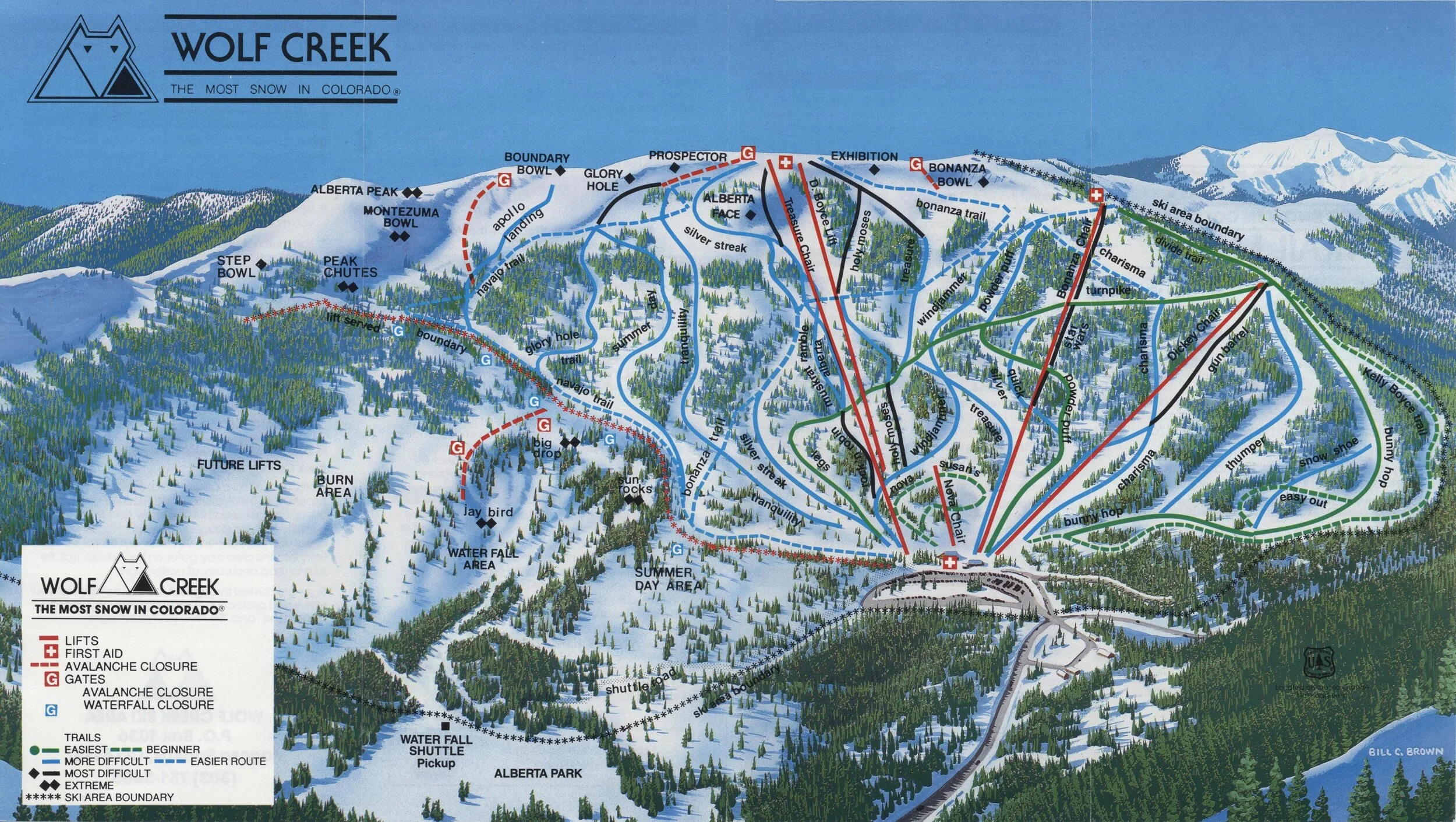
Wolf Creek is known for its powder, and since it is a smaller mountain, you’ll spend less time waiting in line and more time on the slopes.
Mountain STATS
Base: 10,300’
Summit: 11,904’
Vertical Drop: 1,604’
Trails: 120
Lifts: 10
Difficulty Level:
Green: 20%
Blue: 35%
Black: 25%
Double Black: 20%
Acres: 1,600
Average Snowfall: 430”
THE LOGISTICS
Season: Typically opens mid October to early November, season usually ends in April
Hours of Operation: 8:30am - 4:00pm
Pass: Wolf Creek Season Pass
Lift Ticket: $60-$76
TRAVEL INFORMATION
Distance from Denver: 253 miles
Distance from Colorado Springs: 231 miles
Distance from Durango: 84 miles
Distance from Grand Junction: 265 miles
Closest Towns: Pagosa Springs
Things to do: Go tubing, soak in the hot springs, grab dinner at Alley House Grille.